選單
選單 |
 |
|
檔案: |
開啟
- 打開一個現有的TerraExplorer Pro專案檔(.Fly file).
關閉
- 結束本項目和打開起動頁.
列印
- 開啟一個列印視窗列印當前的3D視窗.
離開
- 關閉所有當前視窗及連結.
|
 |
|
檢視: |
工具箱
- 開啟或關閉工具視窗.
飛行模式
- 開啟或關閉飛行模式區.
左上方視窗
- 展示或隱藏左上方應用視窗.
左下方視窗 - 展示或隱藏左下方應用視窗.
全螢幕 - 展示全螢幕3D視野. 妳可以按Alt+enter轉換全螢幕模式.
按Alt+enter或ESC離開全螢幕模式. |
|
巡航: |
拖曳模式
- 抓住地形然後進行前後左右挪移.
滑行模式
- 在3D視窗點擊擊按住滑鼠左鍵. 拖曳滑鼠朝向各個方向. 高程及傾斜角度決定妳的滑行速度.
旋轉及傾斜模式 -
在3D視窗中點擊及按住滑鼠左鍵. 鏡頭中心點隨之影響而改變.當左鍵按住時拖曳滑鼠,朝視窗的八個角度運行離開中心點.
比例 - 選擇改變不同的比例呎: 房屋,道路,城市,省縣,全球.
播放
- 這個選項啟動資訊視窗預設之飛行路徑.
停止
- 選擇結束停止飛行模式.
暫停
- 暫停飛行模式.
起點
- 跳躍至路徑的起始點.
終點
- 跳躍至路徑的終點.
物件瀏覽
- 這個選項允許你檢視不同的飛行物件模式.
圓周飛行
- 沿著3D視窗的中心點繞圈飛行.
朝正北
- 將鏡頭旋轉至面向正北.
|
|
量測: |
顯示資訊
- 展示所選擇物件的確切地點,海拔高度或地理,幾何的屬性資料.
展示資訊在左下方的視窗.
水平距離
- 展示在3D視窗中不同高度.角度的2個或多個點之間的水平距離.
直線距離
- 展示在3D視窗中不同高度.角度的2個或多個點之間的最短距離.
垂直距離
- 展示測量地面與物件的垂直高度.
測量面積
- 在3D視窗中展示測量水平面積.
(更多資訊)
(更多資訊)
(更多資訊)
(更多資訊)
可視域分析
- Opens the properties sheet for calculating the view from any defined viewpoint, along a line or a sector, to an end point in the 3D View.
(更多資訊)
威脅圓頂
- Opens the properties sheet for calculating the volume that is visible from a given point in the 3D View.
(更多資訊)
|
| 工具: |
協同作業
- Allows the user to lead, follow and share in real-time, interactive TerraExplorer fly-through sessions, chat with other users, mark up areas on the terrain, and toggle information layers for further analysis.(*)
GPS追蹤 - Tracks real-time objects that use the NMEA standard.(*)
尋找物件
- Searches for objects in the projects according to the search criteria.(*)
自由手繪
- Draws lines by tracking the mouse pointer movements.(*)
FalconView介面
- Interfaces to information provided by a FalconView application.(*)
Blue Force追蹤
- Tracks real-time objects that use the BFT standard.(*)
Predator Data Feed - Imports Predator feeds and track them using a moving TerraExplorer VideoOnTerrain object.(*)
巡航幫手
- Locks the TerraExplorer camera in 2D modes and continuously tracks the distance and direction to a specific target.(*)
多重座標系統
- Projects the current camera/cursor coordinates to a user-selectable coordinate system.(*)
資料庫
- Set of Graphic elements you can add to your project.(*)
GPS追蹤
- Tracks real-time objects that use the NMEA standard.(*)
GPS追蹤
- Tracks real-time objects that use the NMEA standard.(*)
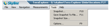
快照 - Opens the 3D window view as an image in a popup window which then enables the user to close, save, print or open the image in a paint program or editor.
儲存快照至檔案 - Opens a popup window to save the image in Bitmap or Tiff file format.
快照尺寸 - Opens a popup window that allows the user to scale the size of the snapshot.
選項
- 顯示選項對話框去設定不同的環境參數.
點擊此處參閱選項對話框的資訊.
(*) - More information available in the tool.
|
|
說明: |
TerraExplorer 導覽
- 在3D視窗中開啟快速導覽手冊.
TerraExplorer 網址 -
在3D視窗中開啟TerraExplorer 網頁.
飛行指示
- 在視窗左下方打開飛行按鍵及滑鼠指示.
關於TerraExplorer -
打開視窗檢視TerraExplorer資訊.
|
|
 C2MP
C2MP